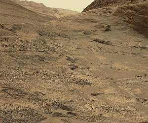
The “road” through Paraitepuy pass continues to challenge our intrepid Curiosity rover. We attempted to cross another large sand ripple (formally called a transverse aeolian ridge, or TAR) in Tuesday’s plan.
However, we found out this morning that Curiosity had automatically stopped the drive when the rover’s wheels slipped more than expected right before they reached the crest of the TAR. While unintended stops like this are frustrating, it’s comforting to know the rover is so capable of keeping itself safe – stopping the drive early is definitely better than trying to plow through and potentially embedding the wheels deep into the sand!
In today’s plan, we’ll back out and try again. Rather than crossing the TAR in the same place, we’re going to try crossing a few feet to the side, where the sand is shallower and therefore should be easier to cross. Unfortunately, there’s another obstacle we’ll encounter right after we cross at this new location, a large rock that’s visible in the above Navcam.
In order to navigate this tricky terrain, we’re planning to stop the drive after we cross the TAR but right before we reach the rock, just to make sure the rover is positioned exactly where we want and so that we’ll be in the best position to plan a safe path around. Paraitepuy pass is certainly testing our rover drivers, but I have complete confidence we’ll make it through soon!
Since we stopped while trying to cross the TAR, we were greeted this morning with another sand-filled workspace. We planned contact science with MAHLI and APXS on a single target, “Yupukari,” that’s along the crest of the bedform. We’ll also be taking lots of remote sensing data, with a ChemCam LIBS observation of targets “Makarapan,” a rock near the rover’s back wheel, and “Uaipan,” a different area along the crest of the TAR.
We’ll collect another long distance RMI mosaic of the mysterious marker band unit (see more), and Mastcam observations of some bedrock behind the rover named “Maturuca,” a float rock in the sand named “Los Viejitos,” another distant rock named “Salgado,” and the rock we’ll need to drive around on Friday, named “Rera.” We’ll also capture additional imaging of the “Bolivar” butte that we have been driving around for the last few sols. Environmental science observations will round out the plan.
Related Links
Curiosity Mars Science Laboratory
Mars News and Information at MarsDaily.com
Lunar Dreams and more
|
We need your help. The SpaceDaily news network continues to grow but revenues have never been harder to maintain. With the rise of Ad Blockers, and Facebook – our traditional revenue sources via quality network advertising continues to decline. And unlike so many other news sites, we don’t have a paywall – with those annoying usernames and passwords. Our news coverage takes time and effort to publish 365 days a year. If you find our news sites informative and useful then please consider becoming a regular supporter or for now make a one off contribution. |
||
|
SpaceDaily Contributor $5 Billed Once credit card or paypal |
SpaceDaily Monthly Supporter $5 Billed Monthly paypal only |
|
![]()
Sols 3562-3563: Adventures Over Sand
Pasadena CA (JPL) Aug 18, 2022
Curiosity is continuing the journey through Paraitepuy Pass. The image above shows why it is going to take some time to traverse through this area. Here the navigation cameras snapped a photo of Curiosity’s wheel tracks over a sand ripple. The rover was designed to overcome terrain like this, but the rover planners still want to develop the drive paths very carefully as we drive through these rocks and sand features.
We decided to take advantage of these sandy adventures, so today we focused our c … read more