by Robert Schreiber
Berlin, Germany (SPX) Apr 17, 2026
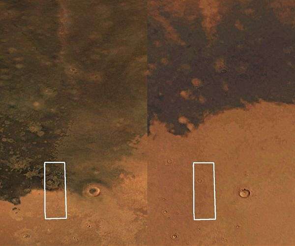
ESA’s Mars Express has captured a blanket of dark volcanic ash creeping across the Martian surface in just decades, a rate of change that stands in stark contrast to the geological timescales that typically govern visible transformation on the Red Planet.
A new image from Mars Express’s High Resolution Stereo Camera (HRSC) shows a scene of two halves, with Mars’s bright tan-coloured sands butting up against dark deposits of volcanic ash. When this part of Mars was seen by NASA’s Viking orbiters in 1976, the ash was noticeably less widespread than it is today.
The dark material is thought to have been made and distributed by volcanoes. Mars has a well-documented history of volcanic activity and hosts the largest volcano in the Solar System – Olympus Mons – which stands at more than double the height of Earth’s largest volcano, Mauna Kea. The volcanic material is rich in mafic minerals that form at high temperatures – olivine and pyroxene being key examples – and give the layer of ash its dark colour. The spread of the ash over the last 50 years has two possible explanations: either it has been picked up and moved by martian winds, or the ochre dust that previously covered the dark ash has been blown away.
A large crater approximately 15 km across can be seen within the blanket of ash. It is surrounded by a striking ring of lighter material known as an ejecta blanket, made up of material thrown out by the impact that formed the crater. Interesting squiggly lines within the crater mark where icy material has moved about inside it.
The scene lies within Utopia Planitia, one of Mars’s colossal impact basins with a diameter of around 3,300 km – just under twice the north-south extent of Earth’s Sahara Desert. Once thought to have hosted a body of water, possibly a lake or even an ocean, Utopia Planitia is now filled with rock and sand but still holds significant water beneath its surface in the form of ice. Many features across the landscape still show signs that water once flowed here.
Some such signs appear in the dark blanket of ash in the form of vaguely rounded pits with wavy edges. Known as scalloped depressions, these features are common in this part of Mars and indicate that the region is periglacial – on the fringes of glaciers or in cold-climate landscapes undergoing cycles of freezing and thawing, with substantial buried ice beneath. Scalloped depressions form as subsurface ice melts or escapes to the atmosphere, causing the overlying ground to become unstable and collapse. They do not occur in isolation but merge to form larger areas, providing a clear example of how Mars’s surface continues to evolve.
On the lighter half of the image, a series of shadowy ditches around 20 km long and 2 km wide stretch across the surface and connect to form a giant shape. These ditches, also known as grabens, form when the surface cracks due to weak points created by layers of wet sediments or tectonic activity. Similar graben structures in Utopia Planitia were featured in a 2016 image release by Freie Universitat Berlin, whose planetary science and remote sensing working group produced the current image products.
The image was captured by the HRSC, one of eight instruments aboard Mars Express. The orbiter has been mapping Mars’s surface at unprecedented resolution, in colour and in three dimensions, since its launch in 2003, returning more than two decades of insights that have substantially advanced understanding of Earth’s planetary neighbour.
The HRSC was developed and is operated by the German Aerospace Center (Deutsches Zentrum fur Luft- und Raumfahrt; DLR). Systematic processing of the camera data took place at the DLR Institute of Space Research in Berlin-Adlershof.
Related Links
DLR Institute of Space Research
Mars News and Information at MarsDaily.com
Lunar Dreams and more